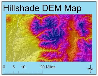
The area that I selected for this lab resides between the latitudinal coordinates of 36.35°N and 36.71°N and between the longitudinal coordinates of -105.78°E and -105.13°E (thus residing within the northeastern region of California). The Geographic Coordinate System used to obtain these coordinates is the North American 1983 Geographic Coordinate System. The area is to a scale of 1:218,735. The elevation in the region shows a spread ranging from ~6,800 ft above sea level to ~11,900 ft above sea level. This spread of ~5,100 ft is best exemplified by the three-dimensional illustration that shows regions in the lowest elevation (~6,800 ft) as a vibrant purple and the highest regions (~11,900 ft) as a reddish-brown. The Aspect DEM map shows that a majority of the slopes are facing in a Southeast direction, which is symbolized by a red coloring. The Slope DEM map shows the slope of not only the mountains and landmasses, symbolized by a lime-green coloration, but it also shows the flow of rivers and the slope of snow packs, as exemplified by the blue coloration on the map. The Hillshade DEM map illustrates the natural shape of the hills by using a grayscale to illustrate the general physical shape of the land. I chose a sunset scheme of colors for this map to represent elevation, with the yellow representing the lowest elevations and the purple representing the highest elevations (while the reddish tones represent the middle-range of elevations).


No comments:
Post a Comment